We have put together a small collection of digital maps you can easily print, paper maps and info regarding cycling routes in the Italian and Swiss Lake District:
- 1. A bike map around Northern part of Lake Maggiore,
- 2. Bike maps on the West side of Lake Maggiore,
- 3. Bike maps in Province of Varese,
- 4. A paper map regarding the Province of Varese,
- 5. A digital map from https://map.geo.admin.ch,
- 6. SwitzerlandMobility: a route planner for rides,
- 7. Cycling climbs map of the Italian and Swiss Lake District.
Many cyclists ask us about tips and advices on how easly get to:
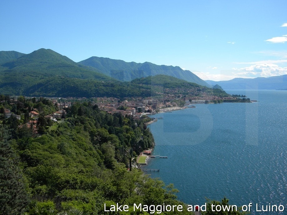
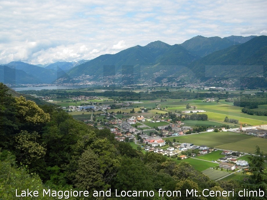
- the lakeside towns of Stresa, Ascona, Locarno, Luino, Laveno around Lake Maggiore,
- the lakside villages of Ponte Tresa, Agno, Morcote, Porto Ceresio around Lake Lugano,
- the typical villages of Cittiglio, Montegrino, Brinzio, Bedero, Gavirate around Varese,
- the cycle paths around.
1. Bike map around Northern part of Lake Maggiore
Eight road bike ride map along the valleys around Cannobio, Cannero Riviera, Brissago, Ascona, Locarno, Maccagno, Colmegna. See the different colors: light blue, black, purple, green, magenta, dark blue, gray, brown.
Learn more: Eight road bike ride description of upper Lake Maggiore between Switzerland and Italy.
2. Bike maps on the West side of Lake Maggiore
-
Cannobio - Saint Anna Gorge,
-
Gignese - Invorio - Armeno,
-
Lake Orta Loop
-
Premeno - Aurano - Intrasca Valley,
-
Stresa - Arona Round Trip,
-
River Toce - cycle path 1st part,
-
River Toce - cycle path 2nd part,
-
River Toce - cycle path 3rd part.
3. Bike maps in Province of Varese
-
road bike routes,
-
road cycling climbs,
-
cycle paths,
We have designed cycling experiences which can involve these routes for all skill levels. They all are paved.
4. A paper map regarding the Province of Varese
Trail Map – Via Verde Varesina – Trekking in Province of Varese, Scale 1:35.000 is another well done map.
That's a paper map which you can find at the local tourist information offices on arrival or here in hotel. In particular the map shows both the trails for trekking and the roads for road cycling in the Norhern area of Province of Varese : among the Lake Maggiore, Lake Varese and Lake Lugano.
The map is very detailed and precisus so you can discover the hidden cycle routes and itineraries in our cycling area.
5. A digital map from https://map.geo.admin.ch
Here's a detailed digital map: MAP SWISS TOPO
Click on (+) map larger, or on (-) map smaller at the top right corner of the screen.
Look at the top left corner of the screen, you can print the area you want on:
- A4 paper size or A3 paper size,
- scale from 1:500 to 1:2,500,000.
You can understand the altitude of the roads and of the routes both in Switzerland and Italy.
www.geo.admin.ch is a portal provided by the Federal Authorities of the Swiss Confederation.
Anyway you can directly dowload a copy of the digital map - Italian and Swiss Lake District, (7MB).
The map is large (29cm x 42cm – 11,41in x 16,53in) and quite detailed.
You can upload it onto your smartphone, so you can use it off-line for crossing the area by bike or by car.
6. SwitzerlandMobility is a route planner for your rides
SwitzerlandMobility is the national network for non-motorized traffic, in particular for leisure and tourism (e.g. hiking, cycling, mountain-biking, skating and canoeing). Routes are subdivided into international, national, regional and local categories.
7. Cycling climbs map of the Italian-Swiss Lake District
100+ cycling climbs in the Italian-Swiss Lake District.
Their names are in native language.

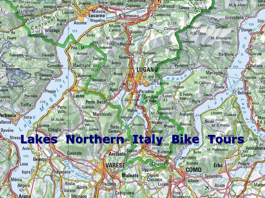
Italian and Swiss Lake District
The Italian and Swiss Lake District stretches across Northern Italy and partly across Switzerland.
It lies on the Southern most end of the Alps, in the area among Lombardy (Italy), Piedmont (Italy) and Canton of Ticino (Italian speaking part of Switzerland). The land around the southern ends of the glacial lakes is relatively flat, but the northern ends are hilly and mountainous, as the glacial lakes reach deep into the Italian-Swiss Pre-Alps.
Lake Maggiore, Lugano, Varese, Como
The four most important lakes are Lake Maggiore, Lugano, Varese and Como.
They are Pre-alpine basins hollowed out by the slow and incessant erosion of ancient glaciers. Between and around there are several minor lakes such as Orta and Mergozzo, West of Lake Maggiore, Monate and Comabbio, South of Lake Varese, and Ganna, Ghirla and Brinzio midway between Varese and Lake Lugano.
There are also others minor lakes such as Pusiano, Alserio, Annone, Garlate, Segrino and Montorfano, South of Lake Como.
Learn more: road cycling routes
The Lake District has good climatic conditions. April, May, June, September and October are the ideal months for a cycling trip. The weather is ideal and you’ll avoid the heat and extra tourist traffic of peak summer. The mild climate of the lakes is attributable to the particular topography of the territory, with the Alps and the Pre-Alps to the North, valleys and plains to the South.
Tourist attractions Map
To help you make the most of your stay on Northern Italian Lakes we have put together a guide, packed full of information about all the tourist attractions to see during your holiday.

 Go back to resources